
The Pentagon was scheduled on Friday to brief Elon Musk on the U.S. military’s plan for any war that might break out with China, two U.S. officials said on Thursday.
Pentagon Set Up Briefing for Musk on Potential War With China
Tag: Reconnaissance satellites
Listening to Soldiers Of Reason: The RAND Corporation and the Rise of the American Empire

Soldiers Of Reason: The RAND Corporation and the Rise of the American Empire
Related:
The Rand Corporation: The Think Tank That Controls America (archived)
By the 1960s, America’s rivals were paying attention. The Soviet newspaper Pravda nicknamed RAND “the academy of science and death and destruction.” American outfits preferred to call them the “wizards of Armageddon.”
Biden confirms that there will be retaliation against Iran as U.S. intelligence leaks reveal Israeli plans.
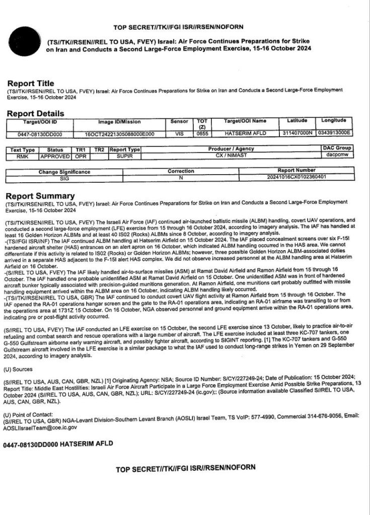
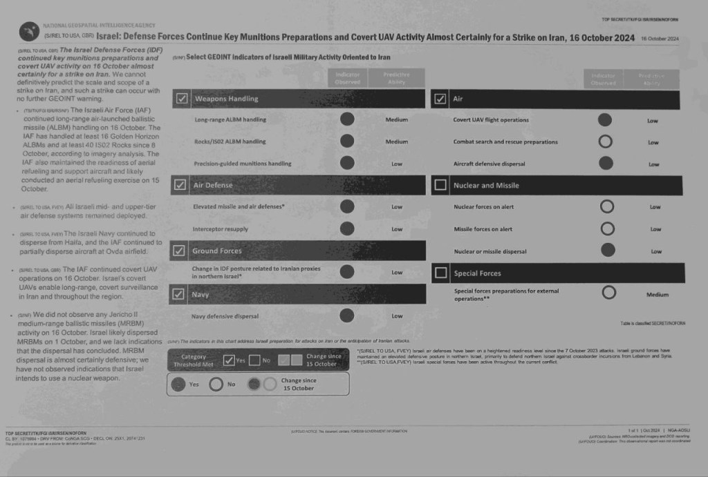
American officials are trying to determine the source of the leak, which describes military drills and weapons placement, and how damaging it might be.
Leaked U.S. Intelligence Suggests Israel Is Preparing to Strike Iran (archived)
Related:
Pro-Iranian account leaks alleged U.S. intel on Israel’s attack plans
Deployment of U.S. Nuclear Strategic Assets Is Root Cause of Ever-escalating Tensions on Korean Peninsula: Int’l Affairs Analyst of DPRK
Pyongyang, December 2 (KCNA) — Kang Jin Song, an international affairs analyst of the DPRK, released the following article “Deployment of U.S. strategic nuclear assets is malignant cause of vicious cycle of escalating tensions on Korean peninsula” on Saturday:
Deployment of U.S. Nuclear Strategic Assets Is Root Cause of Ever-escalating Tensions on Korean Peninsula: Int’l Affairs Analyst of DPRK
H/T: Der Friedensstifter
Papua New Guinea Students Protest US Military Pact
STUDENTS of Mt Hagen Technical College (HATECO) in Western Highlands Province staged a protest march to stop the signing of Defence Cooperation Agreement between PNG and the United States.
Giving the same reasons, the University of Papua New Guinea, the University of Technology and the University of Goroka have all conducted protest marches demanding the Prime Minister James Marape not to sign the deal until and unless the citizens are fully aware of what is entailed in the document.
Papua New Guinea Students Protest US Military Pact
Previously:
US-China rivalry: American troops to access Papua New Guinea ports, airports in new security pact
Chinese scientists war-game hypersonic strike on US carrier group in South China Sea
Hypersonic weapons could be “catastrophic” for the most potent aircraft carrier group in the US fleet, according to war game simulations run by a team of military planners in China.
Chinese scientists war-game hypersonic strike on US carrier group in South China Sea
US-China rivalry: American troops to access Papua New Guinea ports, airports in new security pact
Papua New Guinea will sign a security pact with the United States that gives American troops access to the Pacific nation’s ports and airports, its leader said on Thursday, as Washington jostles for influence in the region with Beijing.
US-China rivalry: American troops to access Papua New Guinea ports, airports in new security pact
CIA satellite tipping Ukraine special forces off about Russian targets
A report says a satellite belonging to the United States’ Central Intelligence Agency tips off Ukraine’s special forces about potential targets belonging to Russia, which is conducting a special military operation in the ex-Soviet republic.
CIA satellite tipping Ukraine special forces off about Russian targets
SpaceX completes record year with Israeli imaging satellite launch
SpaceX completes record year with Israeli imaging satellite launch
EROS C3 is part of ImageSat’s EROS NG constellation, which includes EROS C1 and C2 as well as a planned future imaging satellite, EROS C4, slated for launch in 2026. EROS NG will also incorporate two synthetic aperture radar satellites that will be owned by an unnamed third party and commercialized by ImageSat.


Elon Musk, eager tech salesman to the Deep State

A hair-plug cosmist dreams of military conquest and galactic insemination.
Elon Musk, eager tech salesman to the Deep State
Previously:

You must be logged in to post a comment.