
The UK has just joined the US in an increasingly dangerous space race
In the ‘Star Wars’ reboot, could the force be with Russia and China?
Tag: reconnaissance
About The Source of Those Satellite Images


Twitter Thread by antiwar_soldier (Archived)
As noted by a previous post, six months ago, about Sino-Indian Relations:
Maxar provides 90% of the foundational geospatial intelligence used by the United States Government for national security and keeping troops safe on the ground.
Maxar
Maxar’s customers (think tanks, defense contractors, & intelligence agencies)
Westminster Company Maxar Captures Satellite Images of Ukraine Conflict:
From its headquarters in Westminster, Maxar is keeping the federal government informed about ground conditions in Ukraine. For the past two decades, the company has worked with the National Reconnaissance Office’s EnhancedView program, which allows the NRO — which manages America’s spy satellites — to gain additional imagery from private outfits.
…
Along with the U.S. government, Maxar has partnered with private businesses and overseas allies including Ukraine to provide up-to-date images throughout the conflict. All of the imagery is unclassified.
The NRO pays Maxar $300 million a year to provide imaging along with other data-related services. “Maxar is one of three electro-optical commercial imagery providers on contract with the NRO and provides commercial imagery in support of NRO’s mission in providing data to more than 500,000 government users in the Intelligence Community, the Department of Defense, dozens of federal civil government agencies, allies, and mission partners,” says the NRO spokesperson.
…
Dan Jablonsky, CEO of Maxar, says one of the important parts of the company’s work is providing news organizations imagery that promotes transparency, helps reduce the spread of misinformation, and shows the realities on the ground in Ukraine.
Maxar Technologies — The eye in the sky tracking invasion of Ukraine (Archived):
One of these companies is Maxar, headquartered in Colorado, USA. Maxar traces its history back to the 1960s on its website though its current incarnation’s roots lie in Worldview Imaging Corporation, aka DigitalGlobe…
During the late 1990s and early 2000s, DigitalGlobe forged close links with the US government, being licensed to launch commercial image-gathering satellites – technology that had previously been dominated by the world’s militaries. Contracts in the hundreds of millions or even billions of dollars reportedly followed.
…
The company’s close links to the US government persist. In 2019, NASA awarded it the contract for building a Moon-landing module, while this year Northrop Grumman won a $935m habitation module contract that required integration with a propulsion module being built by Maxar. Three years ago it reportedly sold its space robotics arm MDA for $765m.
NRO’s strategy to buy satellite imagery shaped by thriving commercial market:
The NRO [National Reconnaissance Office] is the U.S. intelligence agency responsible for developing, launching and operating the nation’s spy satellites. It is also the primary acquirer of commercial imagery for the federal government.
…
Maxar Technologies is the NRO’s sole supplier of commercial high-resolution satellite imagery under the EnhancedView contract, a deal that dates back to 2010 when NGA [National Geospatial Intelligence Agency] selected two imagery providers — DigitalGlobe and GeoEye. By 2012, government spending cuts forced NGA to slash its imagery budget by half. EnhancedView subsequently was reduced from more than $7 billion to about $3.5 billion, which led to the merger of the two companies under DigitalGlobe.
The NRO pays Maxar $300 million a year for access to the former Digital Globe’s WorldView-1, WorldView-2, WorldView-3 and GeoEye-1 satellites, as well as the company’s image archive. EnhancedView was a 10-year deal set to expire in 2020 but when the NRO took over the management of the contract, it added three one-year options worth about $300 million each. The agency so far has exercised two one-year options, extending the contract through August 2022.
…
[Chris] Quilty said Maxar is expected to remain the largest supplier of imagery to the U.S. government but it is almost certain that Planet and BlackSky will get some share of the EOCL contracts.
Interesting comments on satellite images and propaganda: Are These Satellite Images War Propaganda?

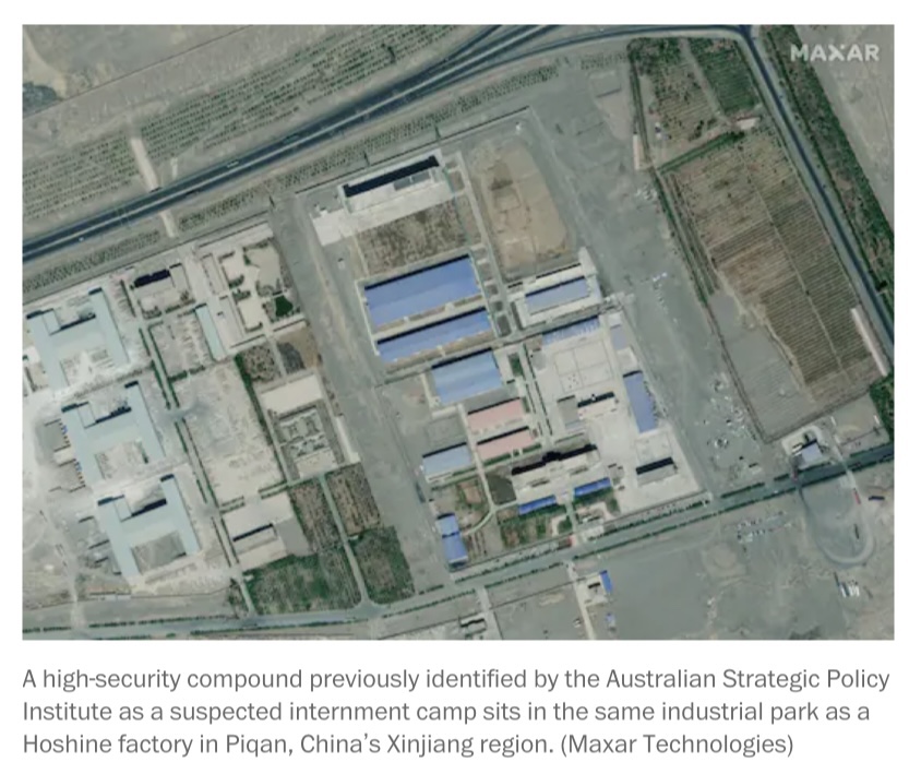
See *Xinjiang* regarding China’s “internment camps & forced labor.”
Related: Bucha Notes
U.S. Air Force Deploys F-35s to Deter Russian Threats to Eastern European
American F-35s, supported by aerial tankers, can help deter Russia with advanced sensors and combat abilities.
U.S. Air Force Deploys F-35s to Deter Russian Threats to Eastern European
Why It’s Unlikely Russia Will Deploy Troops Into Ukraine
Why It’s Unlikely Russia Will Deploy Troops Into Ukraine
One thing is for sure: Unless Kiev starts a massive military campaign in the Donbass, or engages in a serious provocation against Russia, the Kremlin is unlikely to start a war against Ukraine. And even if a war breaks out, Russia’s actions are expected to be very calculated, limited and carefully coordinated with its Western partners, as part of moves toward a “stable and more predictable relationship” between Moscow and Washington.
U.S. surveillance of North intensifies during military exercise
US attempts to monitor PLA submarines with increased spy ship activities in S.China Sea: think tank report
The US is gathering environmental information on underwater battlefields and creating a database that can be used to search for and attack PLA submarines much faster in a possible future battle, Song said.
West Africa is the Latest Testing Ground for US Military Artificial Intelligence
In its preparation for great power competition, the US military is modernizing its artificial intelligence and machine learning techniques and testing them in West Africa.
West Africa is the Latest Testing Ground for US Military Artificial Intelligence

You must be logged in to post a comment.